Dovedale |
|
Dovedale |
|
|||
 |
|||
Britain > Peak District > Dovedale |
The Peak District's principal river |
The Dove is the main river in the Peak District. It starts just south of Buxton, and ends 65 kilometres later when it joins up with the River Trent. The water generally flows south, and for most of its length it acts as the border between Staffordshire and Derbyshire. |
The river's surroundings change a lot over its course. The first section is characterised by desolate moors and brown gritstone. There are a few scattered houses, but the first true settlement is Hartington. It's a small village, but it punches above its weight in terms of shops and facilities. Many visitors to the Peak District choose to base themselves here. |
The Dove doesn't pass directly through Hartington, but it's only half a kilometre away. This section of the river is notoriously good for fishing. In the 17th century an author called Izaak Walton came here many times, and learned a lot about the art of catching fish. He used his experiences to write a guidebook called "The Compleat Angler", which became extremely well-known in its time. On most of Walton's fishing trips he was accompanied by his friend Charles Cotton, who owned a cottage on the banks of the river. You can still see that tiny building today, nestled among the trees. Fishing is a big part of the Dove's appeal so, if you're a keen angler, take along your rod and don't forget your worms. |
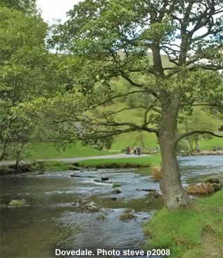
South of Hartington is a tiny hamlet called Milldale. This is the location of the Viator Bridge, a famously narrow stone crossing. In years gone by, packhorses would somehow squeeze themselves across it. Milldale itself is a pretty little place, surrounded by hills and trees. It marks the start of Dovedale, the most scenic part of the river's course. People have been enjoying this attractive valley ever since they've been able to get here. With the spread of road and rail transport, more and more people arrived, and Dovedale became rightfully known as one of the Midlands' most beautiful places. The most popular walking route is right on the banks of the river. You can choose between the Staffordshire side or the Derbyshire side, though it's hard to tell which is better. |
Dovedale features some spectacular limestone scenery, so along the way there are plenty of detours. These rock features come in all different shapes and sizes. Some of them, like the Tissington Spires, stick up into the air in all sorts of weird shapes. They're regularly climbed by the brave or crazy. Another interesting limestone formation is a cliff called Lovers' Leap. The name comes from the legend of a young lady who lived here many years ago. Her boyfriend was a soldier, and one day she received news that he had died in battle. In despair, she threw herself off the cliff. However, her skirt caught on a branch and broke her fall. The young lady gave up and went home, only to be told that her boyfriend wasn't dead after all, and he was on his way to see her! |
There are plenty of other places to explore. Hidden among the trees is Reynard's Cave, with its mysterious ivy-covered entrance. At Thorpe's Cloud you can cross the river on stepping stones, before climbing the hill and enjoying the wide, expansive view. Just south of here the valley ends, and the Dove is joined by the River Manifold. Together they merge into the Trent, and eventually empty into the Humber Estuary on England's eastern coast. |
 |
|
Pocket Britain is optimised for use on a smartphone or tablet with internet access. All content is subject to copyright. All reasonable methods have been used to ensure information supplied is accurate at the time of publication. However, it is advisable to check information before relying on it. Privacy Policy |