Newry |
|
Newry |
|
|||
 |
|||
A historic transport hub and modern retail destination |
|||||
|
|||||
Newry became a city in 2002 during Queen Elizabeth's Golden Jubilee celebrations. It's the fourth-largest city in Northern Ireland but, strangely, not the fourth-largest settlement. By population this is merely a large town but, since it's one of the country's oldest places, it has earned its status. |
|||||
The city sits on the Clanrye River, which is sometimes called Newry River. The locals have yet another name. They just call it "The County", because it acts as the border between County Down and County Armagh. |
|||||
Newry was founded many centuries ago, thanks to a visit from Saint Patrick. He planted a yew tree here, to symbolise Ireland's growing Christian faith. Surely enough, in the next few centuries a monastery grew up around that exact spot. It eventually blossomed into an entire town, which took its name from Patrick's gesture. "Newry" derives from the old Irish phrase: "yew at the head of the strand". |
|||||
The settlement became a garrison, then a busy market town. Despite being nowhere near the sea, it even acted as a port, thanks to an 18th century canal. Newry's prosperity is down to its location between Dublin and Belfast. It's on the main transport route between the two cities, ensuring a constant flow of travellers. Its trade and hospitality industries have always boomed, in both the past and present. |
|||||
Here in the 21st century, the retail scene is based around two huge shopping malls, The Buttercrane Centre and The Quays. Both are right in the middle of the city, next to the canal. Shopping here is so popular that it even attracts people from across the nearby Irish border. The phenomenon is so common that it actually has a name: the Newry Effect. It led to the New York Times calling this "the hottest shopping spot within the European Unions open borders". Conveniently, most stores accept Euros. |
|||||
Aside from these retail paradises, Newry's biggest landmark is The Cathedral of Saint Patrick and Saint Colman. It was built in 1829 for 8,000. This doesn't sound like a lot of money, but it was worth a lot more back then! The architect was Thomas Duff, a brilliant but occasionally absent-minded man. When he was designing Newry's cathedral, he was also drawing up plans for a similar building in the nearby town of Dundalk. Apparently, he accidentally mixed up his documents, so Newry Cathedral was built in Dundalk, and Dundalk Cathedral was built in Newry. Nevertheless, the work went ahead, and no-one could possibly complain about the building Newry ended up with. Its grey towers and turrets dominate views of the city. It's worth going inside to view the intricate mosaic work. A team of Italian craftsmen travelled all the way here to make it, in a project that took 5 years. |
|||||
There's another church, St. Patrick's, on the eastern side of Newry. It's considered to be the very first Protestant church in Ireland. The tower's unusual set of 4 small steeples caught the eye of the author Jonathan Swift. After his first visit to the town, he described the place with the phrase: "High Church, Low Steeple; Dirty Streets, Proud People". |
|||||
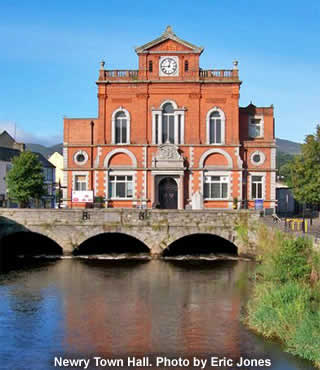
To find an example of this local pride, look at the stone monument outside the town hall. It's dedicated to "Banjo" Bannon, the first Newry native to conquer Mount Everest. The hall itself is another city symbol. Unusually, it's built on a bridge, directly over the Clanrye River. That means that half the building is in County Down, and half is in County Armagh. The councillors can therefore ensure they serve the interests of both regions fairly. |
|||||
Newry's transformation from a single yew tree to an official city has been slow, but steady. Today, nearly 70% of Ireland's entire population live within 70 miles. |
|||||
|
|||||
|
|||||
Newry Tourist Information, Bagenal’s Castle, Castle Street, BT34 2DA. Tel: 028 3031 3170 |
|||||
The Quays shopping centre is open daily, 9am to 6pm (from 1pm on Sunday's). The Quays Shopping Centre, Newry, County Down, BT35 8QS. Tel: 028 3025 6000 |
|||||
Buttercrane shopping centre is open daily, 9am to 5.30pm (till 9.30 on Wednesday, Thursday & Friday and from 1pm on Sunday's). Buttercrane Shopping Centre, Buttercrane Quay, Newry, County Down, BT35 8HJ. Tel: 028 302 64627 |
|||||
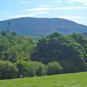
Slieve Gullion Forest Park is open from 8am until sunset. Admission and parking are free. It's 5 miles south-west of Newry City on the B113 Forkhill road. |
|||||
 |
|||||
|
Pocket Britain is optimised for use on a smartphone or tablet with internet access. All content is subject to copyright. All reasonable methods have been used to ensure information supplied is accurate at the time of publication. However, it is advisable to check information before relying on it. Privacy Policy |